Marine Weather Forecasting and Reporting Over Satellite
"May the wind be always at your back." - Celtic Blessing
Besides the deck under your feet, the wheel in your hand, and the water gliding by, marine weather is the most important tool in any sailor’s toolbox. Without it, you won’t know if that light breeze will turn into a squall or if you’re looking at a perfect day.
Pivotel has marine software solutions for every level of sailor – from weekend cruisers to full time commercial fishermen. Plus, weather happens over land, and we’ve got you covered there, too. Looking for simple weather data? XGate includes a marine weather app for iOS and Android. Need local forecasts and a GRIB file viewer? XGate ecosystem partners have you covered. Want custom fishing or navigation information? Optimizer works with some of the world's leading apps.
Read on to learn how Pivotel can keep you connected with the weather information and forecasts wherever you are.
Weather Products
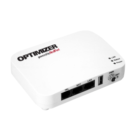
Optimizer
Buy NowMarine Weather Forecasting and Reporting Over Satellite
Request a Consultation
Want weather advice? Contact us or complete the form below to request a free consultation.
Sections
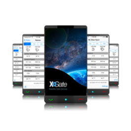
XGate Weather Services
XGate is the world’s leading independent satellite data service, providing email service and weather information from its start in 2002. It shouldn’t be surprising since the original versions of XGate were literally created on a sailboat in the Caribbean by a pair of liveaboards.
XGate compresses email up to 20x compared to standard email services.
This lets you send and receive messages quickly and affordably over satellite and remote cellular services. This means that any regular weather information can be sent to you via email without firing up broadband Internet over a satellite connection, potentially saving you dollars per megabyte and certainly saving you time and headaches.
Beyond weather, you can also get regular updates via email including news, stocks, sports scores, banking statements and more.
XGate Point Weather for iOS and Android
XGate subscribers get free marine weather forecasts right on their mobile devices. The current XGate apps for iOS and Android now provide the compressed weather information you need most via your satellite connection, giving you fast, friendly weather information for multiple locations. Multiple locations: view your current GPS location, select location by airport code, or enter a specific GPS location
3-7 days user-selectable forecasts
1-6 hour display frequency
Metric and Imperial measurements support
Selectable weather parameters including: temperature, surface pressure, wind speed, wind direction, wave period, wave height, visibility, wave direction, rain, freezing rain, UV index, total precipitation, cloud cover, dew point, perceived temperature, and thunderstorm probability, and more.
Point Weather Features Include:
PredictWind Weather Forecasting
PredictWind Weather Forecasting
PredictWind is weather and wind forecasting software with full GRIB file viewer and requester, weather routing, departure planning, and more. Used by tens of thousands of users worldwide, PredictWind is a world leader in marine weather and wind software.
Pivotel Free GRIB File Download Service
We provide an incredibly popular free GRIB file service that has been used by tens of thousands of sailors for more than a decade. GRIB files are highly compressed files bearing weather data that are small enough to be sent over satellite. When used with most any modern weather software, GRIB files provide the information needed to know which way the wind is blowing, literally and metaphorically, and to provide helpful weather visualizations. Fun fact: GRIB stands for "General Regularly-distributed Information in Binary form" and is a WMO (World Meteorological Organization) standard format for archiving and exchanging gridded data.
Weather and Navigation Software over Satellite with RedPort Optimizer
Looking for a different service? The RedPort Optimizer is the world’s leading independent satellite Wi-Fi router and firewall – and the device that enables you to use a whole host of weather and navigational software over satellite devices. Optimizer connects with almost any modern satellite phone or terminal, provides a Wi-Fi connection for easy access from laptops and mobile devices, with a powerful firewall to prevent runaway airtime usage.
Pivotel enables a variety of marine software services for easy connectivity over satellite with RedPort devices. Current services and partners include:
Tracertrak - vessel tracking
GSatTrack - satellite telematics
Expedition Marine - marine navigation software
SeaView Fishing - commercial fishing software
Weather4D - weather forecasting
iNavX - navigation app
We also provide custom development for global corporate and governmental agencies who need to make their apps and services work over satellite. Contact us to learn more.